
Finding pics of the lesser places in Zimbabwe is a real challenge as back in the 70's, very few folk owned cameras and perhaps folk are not as nostalgic as I am to share what they have.
Gwelo (now Gweru 1982) is a city near the centre of Zimbabwe. It is the fifth largest city in the nation. Gweru is the capital of Midlands Province. Gwelo was founded in 1894 by Dr. Leander Starr Jameson.
The first bank opened in Gwelo in 1896, and the stock exchange in 1898.
The railway arrived in 1902. It became a municipality in 1914 and
achieved city status in 1971. (wiki edited)


Chaplin High School where the one and only white Prime Mister of Rhodesia went to school seen here at the official opening of theGeorge Alers Track in 1971.
Ian Douglas Smith enrolled at the Chaplin School in nearby Gwelo for his secondary studies. In his final year at Chaplin, Smith was head prefect, recipient of the Victor Ludorum in sports, and captain of the school's rugby, cricket and tennis teams.[1]
Smith later remarked, "I was an absolute lunatic about sport. I
concede, looking back, that I should have devoted much more time to my
school work and less to sport."
Gwelo was also the home to the Rhodesian Air Force based at Thornhill. It was also a haven to glider pilots and the thermals got the folk gliding the skies very high very quick.


Que Que, (now Kwe kwe) is a city in central Zimbabwe. It is located in the centre of the country (Midlands province)—roughly equidistant from Salisbury (now Harare) to the north east and Bulawayo
to the south west. It is a centre for steel and fertilizer production
in the country.
Kwekwe and neighbouring Redcliff are the headquarters of Zimbabwe Iron and Steel Company (ZISCO),
the country's largest steelworks. It also hosts the Zimbabwe Iron and
Smelting Company, the largest ferrochrome producer, and one of the
biggest power processing plants, ZESA-Munyati.kwekwe is Zimbabwe's richest city in terms of minerals. (wiki - edited)


All I could get in colour of the town.
Fort Victoria (now Masvingo) is a town in south-eastern Zimbabwe and the capital of Masvingo Province. The town is close to Zimbabwe Ruins, the national monument from which the country takes its name.
It is the oldest colonial settlement in Zimbabwe, and grew up around the encampment established in 1890 by the Pioneer Column en route to their eventual destination, Salisbury.
The Old Fort national monument is located in the centre of town, and
was erected in 1891 as one of a series of fortifications to guard the
route from Salisbury to the south. The very first cricket match in Rhodesia is said to have taken place close by in 1890 (wiki-edited)


Fort Victoria Station


Strip roads leading to Ft. Vic and a normal road.
(Original photos here Colin Weyer www.rhodesia.me.uk)
Lake Kyle (pics)
Lake Kyle, lies in south eastern Zimbabwe, south east of Fort Victoria (Now Masvingo). It covers about 90 km² and was created in 1960 with the construction of the Kyle Dam on the Mutirikwe River.
The dam was built to provide irrigation water to the farming estates on
the lowveld to the south west, around the town of Triangle, where the
main crop has been sugar cane. (wiki - edited)


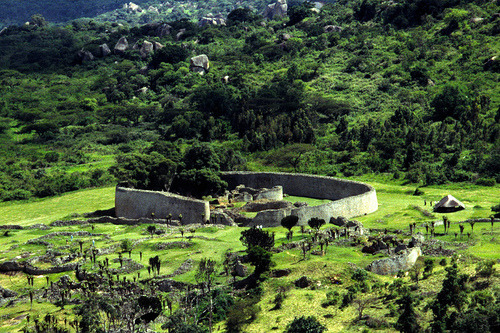
Zimbabwe Ruins (lotsa pics)
Zimbabwe Ruins (or Great Zimbabwe as it is now known) is a ruined city that was once the capital of the Kingdom of Zimbabwe,  which existed from approximately 1100 to 1400 during the country’s Late Iron Age.
The monument, which first began to be constructed in the 11th century
and which continued to be built until the 14th century, spanned an area
of 722 hectares (1,784 acres) and at its peak could have housed up to
18,000 people. Great Zimbabwe acted as a royal palace
for the Zimbabwean monarch and would have been used as the seat of
their political power. One of its most prominent features were its
walls, some of which were over five metres high and which were
constructed without mortar. Eventually the city was largely abandoned and fell into ruin.
which existed from approximately 1100 to 1400 during the country’s Late Iron Age.
The monument, which first began to be constructed in the 11th century
and which continued to be built until the 14th century, spanned an area
of 722 hectares (1,784 acres) and at its peak could have housed up to
18,000 people. Great Zimbabwe acted as a royal palace
for the Zimbabwean monarch and would have been used as the seat of
their political power. One of its most prominent features were its
walls, some of which were over five metres high and which were
constructed without mortar. Eventually the city was largely abandoned and fell into ruin.
which existed from approximately 1100 to 1400 during the country’s Late Iron Age.
The monument, which first began to be constructed in the 11th century
and which continued to be built until the 14th century, spanned an area
of 722 hectares (1,784 acres) and at its peak could have housed up to
18,000 people. Great Zimbabwe acted as a royal palace
for the Zimbabwean monarch and would have been used as the seat of
their political power. One of its most prominent features were its
walls, some of which were over five metres high and which were
constructed without mortar. Eventually the city was largely abandoned and fell into ruin.
Okay that is the official LMFAO wiki spin. Lemme tell you, the Zimbabweans did not build this and is likely to have been linked to the
slave traders and shit to do with some monarchy in North Africa. Come on man,
they had not even discovered the f***ing wheel before the white man
came to Africa and mud huts all over the country, testimony they had absolutely no
masonry skills. This was an advanced culture that died out or left the region. Seeing they have f***ed up much of the country, it is not a legacy to be proud of, you know this part;
wiki spin. Lemme tell you, the Zimbabweans did not build this and is likely to have been linked to the
slave traders and shit to do with some monarchy in North Africa. Come on man,
they had not even discovered the f***ing wheel before the white man
came to Africa and mud huts all over the country, testimony they had absolutely no
masonry skills. This was an advanced culture that died out or left the region. Seeing they have f***ed up much of the country, it is not a legacy to be proud of, you know this part;Eventually the city was largely abandoned and fell into ruin....
One would expect in a culture of oral tradition to have found more of these villages when the white man arrived and also occupied. It is not like there were square rocks lying around to build with. One does not abandon a fortress this well constructed even if an earthquake caused its demise.
Their forefathers may have built it but they were supervised and probably slaves IMO. In 1900+ years of this "advanced" civilisation, one expects to see progression not regression. The big question is WHY did we not find this?
They still build mud huts as THAT is the oral tradition passed down. Then when the owner dies, they burn the frigging thing down.
I suppose in another 200 years folk will see further (modern) ruins and claimants made to the engineering ingenuity of the blacks in the 19th and 20th centuries.
It does seem there is a political twist to the history of these ruins.
Anyway, here are some pretty pictures.

.


