Pages

17 April, 2012

Choosing the right Bra - Humour

For some women, it's easy to find bras that fit in styles they like. But many others aren't so lucky, spending endless time and money in search of that elusive perfect style and fit.


The under wire bra is designed to provide additional lift.


Under wire can be found in many different styles of bras.


Some women swear by their under wire and others find them very uncomfortable.

One way to determine if this is a style of bra that will work for you is to give it a try.

Under wire Bra - from Paris


Under wire Bra - from New York


Under wire Bra - from London

 
Under wire Bra from Brakpan ...

The original under wire bra, proudly South African

Now stop laughing and send this to someone who needs a good laugh!!!

08 April, 2012

Back to Rhodesia for a visit - Salisbury and district.


Salisbury and surrounding areas

Salisbury (now Harare) is the capital of Zimbabwe with a population of 1.6M. It is the largest city and administrative and commercial capital of Zimbabwe and is at an altitude of 4865 feet with a temperate climate. The city is a trade centre for tobacco, maize, cotton, and citrus fruits. Manufactures include textiles, steel, and chemicals, and gold is mined in the area.

It was founded by Cecil John Rhodes, on 12 September 1890 as Fort Salisbury after the 3rd Marquess of Salisbury, the then British prime minister, and subsequently became known as Salisbury. It was declared to be a municipality in 1897 and it became a city in 1935. (wiki - edited)

Note: If you read the Wiki, it looks like a Gr. 7 English level of composition. Pretty fucking sad.

Harare was the original name of the segregated black township.


Salisbury late 60's and early 70's


City Park (Cecil Square) with Jacaranda trees and Flamboyant trees in Suburbia

I worked here in 1978 for about 6 months.  I was based at Lochinvar station, on section as we called it (practical training in the field).  This was at the time when they fired two RPG7 rockets at the fuel storage dumps; that was some huge fire that took weeks to extinguish. The night life here was great and LeCocdor was the place to go and three clubs in one venue catering for all different music tastes. I spent most of my evenings at the round bar and being a fairly decent darts player (played for drinks) was a way to pass the time in a city where I knew few people. I made quite a few friends there albeit short lived. The Rhodesian attitude was everyone was your friend and only if you screwed up were you ousted. I was here as a guest and was treated as such.

The RLI and SAS army folk frequented the round bar and they were easy to spot, they had short hair.

Our section was pretty big and I got to see some of the country side one seldom sees as a tourist.

The Oasis hotel had good Saturday lunch time scenes and a beer garden and if you were lucky, got invited to a private "open party" (bring your own drinks and meat for BBQ - host supplies the music and fires.)

Lake McIlwaine (pics) is a man-made lake and the fourth largest impoundment in Zimbabwe. It was formed in 1952 by the Hunyanipoort Dam and is situated on the Hunyani River some 37 km south west of Harare

Dam wall
Road to lake

To the west of Salisbury was Mazoe Citrus Estates and famous for the greatest orange crush which is available world wide.

The bottle looks like this;
There are also other flavours available.

Mazoe Dam
 
To the east is a park and has these balancing rocks.


Not quite as spectacular as the Matopos in Bulawayo.

Mermaid Pools


Farming

This is what it was like under the "evil white regime" and all you need do is google phrases and see a country in turmoil and not the prosperous land it could have been; had we been allowed to sort out our differences without external political shit.

With all the land grabs by the Mubagbe baboon cadres and "war veterans" who were all were probably in a father's testicles and a mother's ovaries in the time of the actual war, sadly this utopia will be a long time in restoration after the baboon finally kicks the bucket and law and order is restored.

Pehaps they can take a page out of Zambia's book and invite white farmers back and give them back their now unproductive lands.


07 April, 2012

Back to Rhodesia for a visit - Gwelo, Que Que, Fort Victoria (Midlands)


Finding pics of the lesser places in Zimbabwe is a real challenge as back in the 70's, very few folk owned cameras and perhaps folk are not as nostalgic as I am to share what they have.


Gwelo (now Gweru 1982) is a city near the centre of Zimbabwe. It is the fifth largest city in the nation. Gweru is the capital of Midlands Province. Gwelo was founded in 1894 by Dr. Leander Starr Jameson. The first bank opened in Gwelo in 1896, and the stock exchange in 1898. The railway arrived in 1902. It became a municipality in 1914 and achieved city status in 1971. (wiki edited)


Midlands Hotel, Bogie's clock and a street scene
 

Chaplin High School where the one and only white Prime Mister of Rhodesia went to school seen here at the official opening of theGeorge Alers Track in 1971.

Ian Douglas Smith enrolled at the Chaplin School in nearby Gwelo for his secondary studies. In his final year at Chaplin, Smith was head prefect, recipient of the Victor Ludorum in sports, and captain of the school's rugby, cricket and tennis teams.[1] Smith later remarked, "I was an absolute lunatic about sport. I concede, looking back, that I should have devoted much more time to my school work and less to sport."

Gwelo was also the home to the Rhodesian Air Force based at Thornhill. It was also a haven to glider pilots and the thermals got the folk gliding the skies very high very quick.


Que Que, (now Kwe kwe) is a city in central Zimbabwe. It is located in the centre of the country (Midlands province)—roughly equidistant from Salisbury (now Harare) to the north east and Bulawayo to the south west. It is a centre for steel and fertilizer production in the country.

Kwekwe and neighbouring Redcliff are the headquarters of Zimbabwe Iron and Steel Company (ZISCO), the country's largest steelworks. It also hosts the Zimbabwe Iron and Smelting Company, the largest ferrochrome producer, and one of the biggest power processing plants, ZESA-Munyati.kwekwe is Zimbabwe's richest city in terms of minerals. (wiki - edited)

All I could get in colour of the town.


Fort Victoria (now Masvingo) is a town in south-eastern Zimbabwe and the capital of Masvingo Province. The town is close to Zimbabwe Ruins, the national monument from which the country takes its name.

It is the oldest colonial settlement in Zimbabwe, and grew up around the encampment established in 1890 by the Pioneer Column en route to their eventual destination, Salisbury. The Old Fort national monument is located in the centre of town, and was erected in 1891 as one of a series of fortifications to guard the route from Salisbury to the south. The very first cricket match in Rhodesia is said to have taken place close by in 1890 (wiki-edited)


Fort Victoria Station
 
Strip roads leading to Ft. Vic and a normal road.
(Original photos here Colin Weyer www.rhodesia.me.uk)

Lake Kyle (pics)

Lake Kyle, lies in south eastern Zimbabwe, south east of Fort Victoria (Now Masvingo). It covers about 90 km² and was created in 1960 with the construction of the Kyle Dam on the Mutirikwe River. The dam was built to provide irrigation water to the farming estates on the lowveld to the south west, around the town of Triangle, where the main crop has been sugar cane. (wiki - edited)
 

Zimbabwe Ruins (lotsa pics)

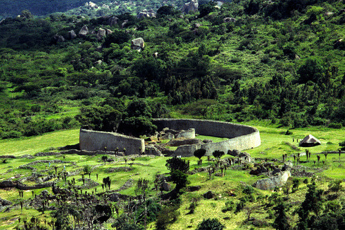
Zimbabwe Ruins (or Great Zimbabwe as it is now known) is a ruined city that was once the capital of the Kingdom of Zimbabwe, :puke: which existed from approximately 1100 to 1400 during the country’s Late Iron Age. The monument, which first began to be constructed in the 11th century and which continued to be built until the 14th century, spanned an area of 722 hectares (1,784 acres) and at its peak could have housed up to 18,000 people. Great Zimbabwe acted as a royal palace for the Zimbabwean monarch and would have been used as the seat of their political power. One of its most prominent features were its walls, some of which were over five metres high and which were constructed without mortar. Eventually the city was largely abandoned and fell into ruin.

Okay that is the official LMFAO :puke: wiki spin. Lemme tell you, the Zimbabweans did not build this and is likely to have been linked to the slave traders and shit to do with some monarchy in North Africa. Come on man, they had not even discovered the f***ing wheel before the white man came to Africa and mud huts all over the country, testimony they had absolutely no masonry skills.  This was an advanced culture that died out or left the region. Seeing they have f***ed up much of the country, it is not a legacy to be proud of, you know this part;
Eventually the city was largely abandoned and fell into ruin....
One would expect in a culture of oral tradition to have found more of these villages when the white man arrived and also occupied. It is not like there were square rocks lying around to build with. One does not abandon a fortress this well constructed even if an earthquake caused its demise. 

Their forefathers may have built it but they were supervised and probably slaves IMO. In 1900+ years of this "advanced" civilisation, one expects to see progression not regression. The big question is WHY did we not find this?

They still build mud huts as THAT is the oral tradition passed down. Then when the owner dies, they burn the frigging thing down.:Doh: 

I suppose in another 200 years folk will see further (modern) ruins and claimants made to the engineering ingenuity of the blacks in the 19th and 20th centuries.

It does seem there is a political twist to the history of these ruins.

Anyway, here are some pretty pictures.

.
Sunset over Lake Kyle

Really all this says is at one time, there lived an advanced culture here and is worth a visit. Who that culture really was will forever remain a mystery.


Back to Rhodesia for a visit - Umtali and Eastern Highlands


Martins Falls
Many of us ex-Rhodesians left shortly after the bush war from the mid 70's onwards to the mid 80's.  As such the many pages you will find on Facebook are proliferated with memorabilia from this war interspersed with day to day civilian life and memories. This was a time when a fit male aged 18 was conscripted to national service and trained to be a soldier where much of the rest of the world, the youth were free to grow up normally.

We did did not have a normal youth and as such developed a culture of allegiance that has lived on in our diaspora all over the world. Our generation has not many years left to tell this story of betrayal and the way we stood alongside each other, revelling in each day as it could have been our last, in a mine detonation or terrorist ambush.


Umtali (renamed Mutare)
Umtali was founded in 1897 as a fort, about 8km from the border with Mozambique, and is just 290km from the Mozambican port of Beira, earning Umtali the title of "Rhodesia's Gateway to the Sea". It is sometimes also called "Gateway to the Eastern Highlands". Zimbabweans refer to it as 'Kumakomoyo' (place of many mountains). There is a border railway station on the railway line from Salisbury (Harare) to Beira with a railways mechanical work shop. (wiki edited)

Umtali in the Manicaland Province, the Eastern Highlands was one of the hot zones of the bush war being the border to Mozambique.

Msasa trees in Spring - Eastern Highlands
I only visited this town once as a youth but it is a beautiful site to behold. I did date two girls from this town.
 
Road to Umtali from Fort Victoria
Umtali street scenes and Flamboyant trees
Umtali Main Street

Troutbeck Inn

Lake and Troutbeck Inn

Chimanimani mountains
Marymount College and mountains

I never got to see too much up close here as we only did the tourista spots we could get to by car.

The area was/is known for the tea plantations and some of the finest tea comes from here (I am biased of course)

Chimanimani Mountains and Melsetter
  

A tad north is the Nyanga National Park

Nyanga (formerly known as Inyanga) is a town in the province of Manicaland, Zimbabwe, located adjacent to Nyanga National Park in the Eastern Highlands about 105 km north of Mutare. 

The highest mountain in Zimbabwe, Mount Nyangani lies about 15 km from the village. Its highest peak rises to 2,600 m above sea level. Nyanga is a popular tourist destination with its trout fishing, golf courses, mountain hikes and holiday resorts.
 
Nyanga National Park, Gairezi Rapids, Nyangombe falls, Leopards Rock hotel
World's View Nyanga
 Vumba Botanical Gardens
 A 100 or so years of colonisation brought western civilisation to the region with agriculture and forestry.  If the white man never came, they would probably still be running around in loin cloths with rudimentary spears. The demise of much of Zimbabwe is testimony to global politics and interrupting the evolution of the black man to become a useful contributor to society. Sadly the evidence speaks for itself with mass exodus of the whites from this once garden of Eden.

A 100 years was not enough to teach them the new world ways.

Acknowledgements for pics Rhodesia Memories various members


About Me

My photo
Kriel, MP, South Africa
I hail from South Africa and my name is Bernie.